
Oklahoma House Unveils Legislative Redistricting Plan
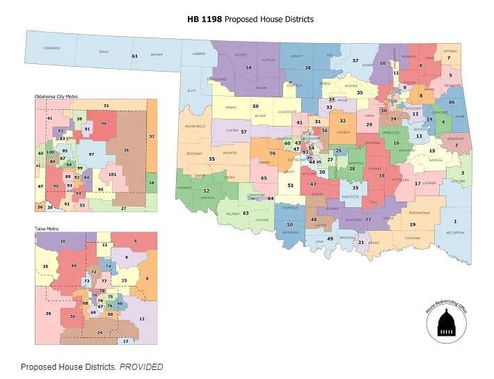
OKLAHOMA CITY – The Oklahoma House and Senate unveiled new legislative district maps last week, revealing a plan in which no incumbents would be forced to run against each other.
“These districts are based on unprecedented public input gathered through the most town halls ever held, several committee meetings involving every House district, and public map submissions,” said Republican Rep. Ryan Martinez, chair of the House Redistricting Committee, in a written statement.
“By putting the public in the driver’s seat, the House was able to produce a very strong map providing fair and proper representation for all Oklahomans for another 10 years,” Martinez said.
The state Constitution in Oklahoma requires the state legislature to adopt new legislative districts by the end of session, so lawmakers said they relied on the best data available — the Census Bureau’s American Community Survey from 2015-2019 — to set the new House and Senate district boundaries for the state’s growing population that’s estimated to soon top 3.9 million people.
The result is a map in which many districts are more compact, and fewer have a mix of urban, suburban and rural areas.
Martinez attributed the changes to a “massive” population shift from the state’s more rural areas to its cities and suburbs.
He also said voter registration wasn’t considered in the drawing of the lines, but that three majority African American districts and one majority Hispanic district were all retained.
He and several of his colleagues said they won’t even attempt to redraw the state’s congressional maps until fall — after the U.S. Census Bureau is expected to release final numbers from last year’s population count that’s required every decade.
The Bureau has said release of the data will be delayed until Sept. 30 due to the pandemic.
The current plan in Oklahoma is for the legislature to reconvene in special session to do the congressional redistricting and make any necessary adjustments to the state legislative districts based on the final Census data.
“Redistricting is a key aspect of maintaining the integrity of our democracy,” said state Rep. Daniel Pae, co-chair of the House Redistricting Committee.
“The House’s transparent, inclusive and accessible process produced a plan ensuring every citizen’s voice has equal weight and representation at the Capitol,” the Republican continued.
Before drawing the new maps, the state House and Senate held a series of 22 town hall meetings — 18 in person and four virtual — to solicit input from the public.
Prior to the meetings, which were held from December to March, the public was invited to attend, ask questions, submit testimony and talk to lawmakers and staff about what makes the most sense for their community.
Meetings were livestreamed, when possible, and recorded and archived.
Previous House meetings can be viewed here.
The House also used a dedicated email address, [email protected], and website, https://okhouse.gov/Publications/Redistricting.aspx, to accept public comment, answer questions and keep the public informed throughout the redistricting process.
In another noteworthy move, and for the first time in state history, all House members served on one of eight Regional Redistricting Subcommittees to ensure representation of all House districts in the process.
The full State and Federal Redistricting Committee set policy for the redistricting process.
In October 2019, a group called People Not Politicians launched an effort seeking to transfer the power of redistricting from the legislature to a bipartisan commission.
However, that effort was abandoned last fall due to a series of challenges including coronavirus-related delays in signature gathering.
After the new maps were released, Andy Moore, executive director of the organization, took to Twitter to observe that the new state legislative districts “look remarkably similar to the existing maps and are clear evidence that the politicians are content to maintain the status quo.”
“Furthermore, it’s almost impossible to determine exactly how the maps compare since they released them merely as images and not in any useful electronic format like they required of the public,” Moore continued in a second Tweet. “Good government begins with good maps, and the legislature can and should do better.”