
FCC’s Broadband Mapping Tool First in a Series
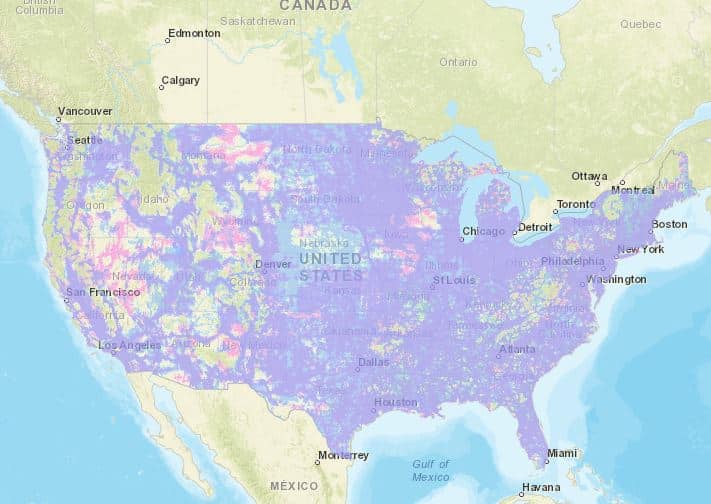
Are you on the map? The Federal Communications Commission map showing where broadband coverage is reaching, that is. Last week the FCC launched its first data map as required by Congress under the 2020 Broadband DATA Act.
The voice and data mobile coverage map is a sneak peek at what the public should expect to see in the series of maps the FCC will be launching under its Broadband Data Collection initiative, a spokesperson told the Well News.
Anyone can use this mapping tool to find where broadband service is available near them. More specifically, it will pinpoint where 4G LTE mobile broadband and voice services are available – voice service does not require the same network speed as data transmission. You can look up your address or location and see the coverage, or it can tell you where you can find 4G coverage nearby to have better call service, video downloads and app response.
While the first maps are based on information from each of the nation’s four largest wireless carriers – AT&T Wireless, T-Mobile, U.S. Cellular, and Verizon Wireless, representing the vast majority of the wireless market – new maps will include information from all mobile and fixed broadband service providers, including fixed wireless and satellite providers.
These wireless service providers will be required to update their broadband availability data every six months, the spokesperson added. There will be forums where the accuracy of the maps may be questioned and improved by information from communities, state, local and area representatives, as well as other stakeholders. Adjustments must be made quickly during these six-month interim periods if any of the data is successfully challenged.
All of this is being worked out by the Broadband Data Task Force at the FCC, according to a released statement by Acting Chairwoman Jessica Rosenworcel. Moreover, the new maps will help policymakers make decisions about closing the digital divide usually found between richer and poorer communities, or rural and populated areas.
The data from the wireless carriers will be standardized, so it will be easier for policymakers to work with. The maps will be used by the agency to better direct support efforts to the identified gaps, the spokesperson said, like the FCC’s largest emergency funding effort under the $7.2 billion Emergency Connectivity Fund announced in late July to bridge the digital divide in education, known as the homework gap.
The FCC could not tell the Well News when the next steps will be taken or when the next maps will be issued, but this effort appears to have successfully produced a user-friendly online tool for the benefit of both the users and the policymakers.